Lake Bathymetric Survey
Scheduling a bathymetric survey of your pond or lake can give you an accurate idea of the irrigation water available for your golf course and the bottom sediment buildup. We can provide extremely accurate data to help you make decisions to better manage your water source.
Benefits of Drone Surveying and GPS
Using dual frequency sonar, advanced GPS, and autonomous equipment, we’re able to quickly and effectively conduct a complete water survey. Benefits include:
- No need to drain the lake to measure sediment or water depth, protecting marine plants and fish.
- Sonar accurately maps the existing bottom of the water or top of the sediment. Using design data and low frequency sonar feedback, we calculate sediment depths. Our volume report provides very accurate water inventory.
- The advanced GPS system provides precision location performance, resulting in highly accurate measurements. Continuously uploaded data allows us to provide immediate lake condition feedback before we leave your course.
- We maintain accurate mission logs for future comparison of sediment fill or to evaluate dredging results. Repeating the exact survey over time can provide valuable insight.
- Our autonomous platform and non-intrusive equipment reduces disruption and visual impacts of the lake survey at your course.
- A full report with accurate bathymetric maps provides post-survey documentation of lake conditions.

Assessment
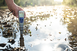
To best understand you needs, we conduct assessments of your soil and water. This includes algae identification, water chemistry, soil analysis, turf evaluations, etc. We ensure we understand your situation thoroughly before providing solutions.
Monitoring and Testing
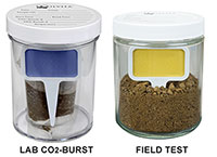
We utilize advanced technologies such as Solvita soil microbial analysis, MicroBiometer soil carbon and bacteria:fungal ratio monitoring, and LuminUltra GeneCount DNA and ATP testing of water microbiology. Our algae testing partners — EnviroSource Labs, completes detailed algae characterization laboratory analysis. We use onsite and laboratory tools to truly assess and monitor the progression of water quality improvement using ultrafine bubble technology.
Follow up and Monitoring
NanoOxygen Systems doesn’t just sell you a system. We maintain ownership and monitoring of your system over the lifetime of the application. This includes remote monitoring of system operation and continued site visits and assessments as part of our ongoing maintenance and monitoring programs. We are by your side every day to ensure you are getting the maximum value of your system.
System Installation
Our team of installers manage the entire process of your particular application. We have two main focus areas – algae control and irrigation water quality improvement. We have the staff that knows both areas well and their experience is invaluable in the building and startup of your system.
Diagnostic Tools
Beyond water chemistry and soil testing, we offer tools such as dual frequency sonar drone bathymetric surveys of ponds and lakes to assess sediment and solids in your lake. We can re-run our drone missions over time to evaluate changes in your lake from ultrafine bubble treatment as we remove organic “muck” from the bottom.
Consultations
Based on the data collected on your water, lake, soil, etc.—we then formulate a plan of attack to improve your situation. This includes bringing advanced technology and systems to the forefront to address what we find.